My personal blog as a 'grown-up' Goth and Romantic living in the Highlands of Scotland. I write about the places I go, the things I see and my thoughts on life as a Goth and the subculture, and things in the broader realm of the Gothic and darkly Romantic. Sometimes I write about music I like and sometimes I review things. This blog often includes architectural photography, graveyards and other images from the darker side of life.

Goth is not just about imitating each other, it is a creative movement and subculture that grew out of post-punk and is based on seeing beauty in the dark places of the world, the expression of that in Goth rock. It looks back to the various ways throughout history in which people have confronted and explored the macabre, the dark and the taboo, and as such I'm going to post about more than the just the standards of the subculture (Siouxsie, Sisters of Mercy, Bauhaus, et al) and look at things by people who might not consider themselves anything to do with the subculture, but have eyes for the dark places. The Gothic should not be limited by what is already within it; inspiration comes from all places, the key is to look with open eyes, listen carefully and think with an open mind..

Showing posts with label travels. Show all posts

Saturday, 9 February 2019

Clava Cairns Revisited

Another instalment of my 'Gothic Travels', which is something I want to focus on this year. Today's visit is to a 4,000 year old burial ground in the valley south of Culloden. I've been there before, and you can see the previous post (with really terrible photographs!) about when I went there for a Pagan gathering ::here::.


On February 4th, my partner Raven and I visited Clava Cairns near Culloden. We drove there, and parked up at the carpark on the site, which only had a couple of other vehicles. I was surprised that there was anyone else there at all on such a cold and frosty Monday afternoon; the carpark was iced over with compacted snow for the most part, and while it wasn't utterly freezing, it was cold enough not to melt the settled snow particularly fast, and even in what is a sheltered valley there was as a certain chill - perhaps the damp air from the river that runs under the viaduct further along. [The viaduct is pretty impressive, similar to the Glenfinian Viaduct made famous in Harry Potter, and it too has a railway crossing a valley, but this one is pink rather than grey; I will give it its own post]. 

Long shadows from a low sun beside the ring cairn; photograph by me.

I apologise for the lack of clarity and resolution in my photos - my camera broke last summer and I haven't been able to afford a replacement since then, so I'm just using the camera on my phone, which is average at best. Please click on photographs for expanded versions, especially the thumbnails.

Pile of rocks in the carpark. Photograph by myself.

There's what appears to be a small cairn in the carpark, just outside the boundary to the main complex of cairns. As it's not listed on the maps, and it's not in the enclave, I think it might just be a pile of rocks from levelling a flattish plot to make the carpark, or maybe an 19thC folly addition, or even stones removed in the 19thC excavations of the cairns; basically I don't know what it is at all.

Frozen meltwater in a depression. Photograph taken by myself.

Raven and I; cooperative selfie.
Clava Cairns is specifically 'Balnuaran of Clava', as there are other groups of cairns known as 'Clava Cairns'. There's also a ruined chapel and another cairn at the far end of road, which I have visited before in the past, but didn't visit that day. Nearby there are two other cairns in an overgrown field across the road from the enclave run by Historic Scotland, and also a standing stone in a field that sometimes has I think cows in it. Either way, the other two monuments and the standing stone are not open to the public as monuments, and while there is some freedom to walk in Scotland, these fields often have livestock, so going in them could cause a problem (Highland Cattle/Heilan' Coos are very cute but they are large animals with big horns! Be considerate of cattle and farmers if visiting.

The setting sun makes for a beautiful light over the cairns.

Reflected sunlight on ice.
Photograph by myself.
The enclave around the cairns is of old trees, planted between 1870 and 1871 by the land-owner at the time, who had the Romantic notion of the cairns being a 'Druidic temple' so wanted to plant it into a 'Druid Grove' - I think there are a few Neo-Pagans (Celtic, Druidic and otherwise) who are quite grateful for that, because it really does give the site a beautiful atmosphere of being encapsulated by nature, something simultaneously apart from the world and deeply within it. I'm certainly neither the first nor the best photographer to take advantage of the late afternoon light streaming between the branches and trunks of the trees, and I felt that the melt-water and ice from where the snow had been defrosting certainly did something to make that extra-special.

Sunlight streaming through the trees across where the snow has melted.

Near-to-carpark cairn. My photo.
The cairns are approximately 4,000 years old, and they were used as mausoleums of a sort. There are three large cairns and one small kerb cairn. Two of the large cairns have passage entrances aligned with the setting sun on the winter solstice, and the centre cairn is a ring cairn - a central sealed chamber with no entrance, a sort of stony donut. I've read that the stone circles around the cairns were set after the cairns ceased to be used for new burials. The ring cairn in the centre of the three is almost a wheel design, with the ring cairn as the hub and low stone walls as spokes out to the standing stones beyond. I think the standing stones are also on a celestial alignment.

A cleft stone - was it split by time and ice, or is it a pair?
Photograph taken by myself. 
Scarf to keep my ears warm.
Selfie by the larger cairn.
The far cairn is the smallest full cairn other than the kerb cairn. There used to be an infographic explaining the sunset alignment at the cairns, but I can't remember if it's still there, and if it was, it was buried under snow. I think the far corner cairn has a cup-mark in a stone within it, and was re-used as a columbarium around a thousand years after they were made, in approximately 1,000BCE. It was excavated in Victorian times, but it wasn't excavated with the modern techniques of archaeology, and a lot of data was missed, lost, or destroyed. I don't know if they disinterred any remains, and if so, what happened to the person who was buried there, but from what I gather, the cairn was the victim of overenthusiastic dilettante archaeology in the 1870s.

The far cairn, aligned with the sunset. Photo by myself.

In South East England, where I grew up, there was a theory relating the placement of barrows to either be prominent on the brows of hills, or to be near rivers, and while I think the builders of the cairns at Clava may have been culturally different, the cairns are hardly on a hilltop, but they are in a valley with the River Nairn flowing through - but I'm not an archaeologist (yet... I'm doing my second undergraduate degree part-time, studying joint History & Archaeology), and it is something I would have to read up on. There's been some interesting papers on the placement of chambered cairns on the Isles, but I don't know about the mainland. Definitely something I need to look into. 

Frosty ground. Photograph by Raven.

The Cairns are very popular in recent years due to the success of the show 'Outlander', as apparently there is some connection to the series. I haven't watched much of it, and the opening scene with early 20thC 'Druids' was filmed on a set on a hillock with foam stones, and Clava Cairns is apparently not the site mentioned in the books (a better candidate for that would be the stones that remain of the cairn at Dunain, which I mentioned in my previous blog entry about Ostara), so I'm not sure what the exact connection is, but it's something to do with magical standing stones as part of the time-travel in the story, from what I gather. They've actually become too popular, and have been damaged by people climbing on the stones, and on the cairns, dislodging parts of the rock walls of the cairns. Large coaches and heavy traffic have also caused an access issue for the garage that runs recovery/road-side assistance from a little further down the road - and therefore for the clients they were off to rescue from mechanical trouble. If visiting during busy season, I would suggest parking elsewhere and walking down, as it is a pretty and pleasant walk (there are also several B&Bs, chalets, etc. nearby for accommodation.).


A rather rectangular stone. Photo taken by myself.


Raven. Photo by me.
The ring cairn was buried under snow, as was a stone with cup-marks tooled into it. When we got to the far end of the cairns, a tour-bus arrived with a medium group of tourist, and the peace of the place felt broken, so we walked off to get a better look at the viaduct instead. I must go back there again this year, and take photographs in different weather and seasons. I follow #ClavaCairns on Instagram, and a lot of beautiful photographs turn up in that hashtag, which is quite inspiring. Hopefully I'll be able to afford a new camera soon, and thus able to work on bettering my photography. For now, I am doing my best with my smartphone and some basic editing software. 

Snow in the dying light; photograph by Raven 
As a historical site, I thoroughly recommend visiting them, just to get a sense of the size and scale of these cairns. As a Neo-Pagan, I visit to reconnect with the sense of place, with spiritual ancestors and those past practices that inspired me to a nature-based spirituality. 

We made a tiny snowman made from two snowballs with twigs for arms. 
It's also just a pleasant place to be. There are some picnic tables near by, plenty of wildlife lives in the area, and the trees are rather lovely. Apart from solemn contemplation, it's nice to enjoy yourself, and I don't think it is any disrespect to those who were buried there thousands of years ago - as long as that doesn't spill into the sort of exuberance that could damage the monuments or make it so other people can't enjoy their time there too.
[My apologies for the formatting errors with the pictures; the blogging wizard keeps putting breaks/paragraphs where I don't want them, even when I remove them in the HTML editor...]

Thursday, 7 February 2019

The Sacred Well and the Howling Moor

This year I hope to put up more posts based around Gothic tourism - visiting places such as ruined castles, ornate graveyards, ancient monuments, great cathedrals, etc. Today's post is of a windswept moor - which if you have read 'Wuthering Heights', you'll know is a very Gothic sort of landscape. To get there, I went up through Culloden Woods, which has a clootie well now dedicated to St. Mary. Culloden Wood also has a ruined mausoleum once home to the remains of various members of the Duncan Forbes family of Culloden House, but I forgot to walk to that part of the woodland and take photographs - this I apologise for. As usual, click to enlarge thumbnails.

My intention was to walk all the way up to Culloden Battlefield, but I left too late in the day, and it was getting dark by the time I was up near the Battlefield, and I wanted to get back to the city before dark (especially as I didn't want to wait around in the Battlefield carpark for a bus, as it is windy and exposed up there, so quite chilly). Culloden Woods is easily accessible from Inverness City Centre by bus. There is also a bus up to Culloden Battlefield directly, as implied earlier. The weather was wet - drizzle and sleet down in the city, but snow up on the hill with the moor. The precipitation came in patches and flurries, with still moments in between. The skies were low and grey, and the sun seemed dim and always closer to the horizon than I wanted it to be.

The Bridge with the oak tree growing on it.

Culloden Woods is forestry pines - cultivated for timber, but it seems to be transitioning to more natural woodland, with areas of birch and more native pines, as well as the new 'Douglas Wood' section that is intended for children and is dog-less (hence the name; naming things with puns is pretty common up here!). There's a railway line cutting the woodland in half, and over that railway is a handsome Victorian railway bridge... with an oak tree growing on it!

St. Mary's Well in the rain.

Clootie well. Click to enlarge.
What I wanted to visit in the woods was the clootie well. A clootie well is a well where 'clooties' or cloth strips are hung around the well for some folk-magic or quasi-religious purpose. With St. Mary's Well at Culloden, the water is supposed to have healing properties, and to use them, you must tie a clootie dipped in the water to a tree above the well, with the sickness or disease disappearing as the cloth decays - I hope all those who hang non-biodegradable things on the trees around the well don't hope for healing! (I imagine there are many that are tourist mementos). There's more to the 'ritual' -if you would call it that - than this, but I can't remember all of it. I think there was once a plaque explaining how to 'use' the well, but it's now gone. 

Clooties on a tree near the well.

St. Mary's Well is not the only clootie well near Inverness - there's also the Well of the Spotted rock above Craig Dunain on the opposite side of the city, and a few others a bit further afield (Munlochy and Avoch both have one), plus there are other springheads with cultural distinctions of one sort or another - bits of history or folklore attributed to them. Clootie wells seem quite common in Gaelic countries - plenty in both Ireland and Scotland - but there are a few in England too. Wales has sacred wells, too, but all the ones I have come across do not have the practice of tying cloths near them, and are more specifically attributed to saints - usually 'Celtic saints', early saints from the Christianisation of the area. Perhaps I will visit more of the local sacred/special wells, and write about them on this blog. I already have a brief mention of the Well of the Spotted Rock planned for my next blog entry.

Blurry photo of a burn (stream)
There's several burns running down crags, which are both rather beautiful and fill the forest with the enchanting sound of running water. When I was there, it was raining, and very slippery, so I didn't get to photograph the crags well as I was slipping and sliding all over the place, hence there being only one rather mediocre photo of the burn near the path up the hill. Maybe if I go back up there, I'll take some more pictures of the forest itself.

I headed back down from the clootie well to the path along the forestry track, which leads out into cleared land that has reverted to a sort of moorland. It's windy and open, but quite beautiful. It had snowed a few days before, and the drainage channels redirecting burns through the land had frozen, and then started thawing, so there was fractured ice floating. It snowed again properly a few days later. There were a few patches of snow on the cleared land, but I didn't get any pictures. The low shrubbery and wild plants seem to close in around you, despite the wind blowing across and the distinct lack of trees other than a few lonely deciduous trees, birches mostly, stand scraggly and stranded out in the open.

View out of Culloden Woods into the cleared land.

One thing out on the open land that I don't want to either romanticise or sensationalise, but I feel should be mentioned because it is a part of the history of that land is the Prisoner's Stone. This isn't something I want to promote as something to visit because it's 'cool and spooky' or something, it's a place to pause and reflect on an atrocity that may have happened over 200 years ago, but which a lot of local people still feel strongly about today.  It's a site where something really horrible happened in the aftermath of the Battle of Culloden - 17 Jacobite prisoners were executed there, for being on the wrong side an 18th man was spared to spread word of what had happened. There's a bench, inscribed in both Gaelic and English; 'Murder of frozen souls here - marvel that I remained alive, to tell' is the English translation. I don't know if being killed on the moor was better or worse than the fate of those taken prisoner and forcibly marched to be 'tried' and executed in London, many of whom died on the journey. All of it is awful.


The Prisoner's Stone

The same surnames on the clan markers on the Battlefield are the surnames of co-workers, friends, and neighbours; there are still people for whom the dead are names in the family tree. It wasn't something I knew people felt very strongly about until I met some of these people at a protest against luxury housing being built on land that was part of the battle and likely has corpses on it, who were very upset because it was members of their family who died in the battle, and who couldn't collect their sons, brothers, husbands etc. after the battle because of fear of the Hanoverians, even if they died centuries before and had never met. They spoke quite passionately, and before that I didn't realise that it was such a personal thing for some still. Ancestry is very important to some people, even if it's not something that's as meaningful to me; I've always felt sort of detached from my long-dead blood ancestors, but a deeper connection to figures in history who align more with how I think, some of whom I am quite sad I can't write letters to! Since meeting those people, I've felt like it's important to treat it as a the site of something nasty in history, and while I think tourism is an important part of transmitting history, it shouldn't make the nastiness seem 'fun' - I think the bench is a good idea; gives people somewhere to sit and reflect on what happen, and what can get people to feel justified in killing each other.

The Gaelic inscription on the simple bench.

Beyond the Prisoner's stone is plenty of cleared forestry land, leading up to the road. The path I took wasn't that one, however, as I went between some leafless fruit-trees along a more sheltered footpath that runs alongside a farm track to the main road, and is part of the official Culloden hiking/walking trail.  

Walking towards the clouds on the moor.
After crossing the main road, I took a path continuing the hiking trail that leads past some houses to more cleared forestry land, windswept and dreary with snow-clouds closing in. There are stands of pines still (mostly) standing, except for those blown down by the wind. I continued out, and every now again the forestry path turned walking trail would open out onto glimpses of the valleys and snow-covered hills below. This far up the hill, there were plenty of patches of snow left and even when the breeze was light, it felt chill. The clouds were not just dimming the sun, but faint hues in them made me suspect that it wasn't rain, but more snow that was to fall.

The sun begins to set over the dregs of snow.

Along one path I took, all the trees that had been the exposed edge of the stand of pines had blown over, and the craters left by their roots had filled with water - meltwater, I would guess. The land there is moorland, crossed by a multitude of burns that I could hear, but could not see through the dense scrub (mostly whin bushes, a type of gorse, but with all sorts of other more damp-loving plants between, and then the odd young and bushy pine), and a mixture of hard and rocky patches of uneven glacial land and wet ground that tried to steal the boots off my feet each time I stepped in it (I tried to circumnavigate a section of path that was flooded, ended up taking a detour that led nowhere useful, and headed back). It's an eerie place to be. 

Snow clouds and felled land. 
I had headed off in the opposite direction to the battlefield to admire the scenery first, and maybe find a shortcut to Clava Cairns, but my detour delayed me and between the heavy cloud and the rapid decline of afternoon into evening, I was loosing daylight so I headed home - or at least to a bus stop first!
🌲🌲🌲

I have several more posts in the 'Gothic Tourism' category to go up - Clava Cairns, Brodie Castle, and several graveyards, ruins, etc. that I visited last year but never had the time to process the images from. 

Sunday, 12 August 2018

Cardigan/Aberteifi - Castle and Historic Church

As I mentioned in my previous post, I was in Wales a few weeks ago, visiting my Dad. While I was there, I visited three castles and a few old churches. I'm not sure quite how 'Gothic' in the spooky sense of the word this is, but it is Gothic in the architectural sense. It's hard to feel spooky on a day with such bright sunshine - glorious for many, but too warm for me!

This post does include a spider photograph, so if you're averse to spiders, then don't scroll past the ornate door. I have put it as the last photograph so you can still appreciate the others without having to look at spiders. 


Restored curtain wall, Cardigan Castle. Photo by me.
Cardigan/Aberteifi is on the River Teifi, and we went there to visit the indoor market, and have a look around. I had had been there before, and knew it had a castle, and it was restored in 2014 (which I had read about). The first time I had been to Cardigan was before that, and while I think local council owned it at the time, it was in disrepair after having been neglected by its previous owner and inhabitant for many decades. Unfortunately, while the entrance fee was modest, I didn't have enough money on me, so I didn't get to go inside the grounds. From what I gather, most of the buildings on site are later, but it has nice gardens, and I was hoping to at least look at the gardens, but it was not to be. I did take a couple of photographs of the exterior, however.

Secondary wall, embankment, and then primary wall with tower...
And a much later additional house/cottage, affiliated with the castle. Photo by me.
Another gem was a rather lovely medieval church that has been extended several times over the centuries. The church is The Priory Church of Our Lady of Cardigan (I don't know what that is in Welsh, although I did read it and I've since forgotten it). It is in a very beautiful graveyard, and next to a hospital but also next to a busy road. I did take some exterior photographs, but they didn't turn out very well. I apologise for no good overview photographs. My partner Raven also took some nice photographs, so with his permission, I have included those too. 


Photograph by myself. Gravestones in rows through yew trees.
The graveyard is mostly older graves, although I did not go around and get a particularly good average for the estimate age - looked like mostly 1700s and 1800s gravestones.They are almost all made of the same sort of grey stone as the church and the castle, and most are a slab given a roughly arched shape with text - not like some of the Protestant chapel yards, full of urns and obelisks, or a chapel on a hill we visited, which had a much wider variety of stones. (Unfortunately I accidentally deleted many of the photos of that particular chapel! )


Photo by Raven. 
This is the far corner of the graveyard. All along the back wall are grave-stones laid vertical, with the climbing plants sort of taking over in places. I don't know if they are memorials from plots that were re-used, or if this is just where fallen-over stones got placed, or if there were just a lot of people buried along the wall. 

I also think this photo goes to show what a bright and sunny day it was - very hot, a few wispy white clouds, and scorching brightness. Personally, I found it too hot; I overheat easily and get sun-burnt just as easily, so I prefer cloudier, cooler days. Some people love the sun, but I have to hide under hats, long-sleeved floaty clothes and lots of sun-screen.  
 
Dead Tree. Photo by Raven 
I'm not sure what kind of tree this was when it was alive. There were plenty of yew trees, but yews are poisonous to other plants, so I doubt that there would be other plants growing from it if it were a yew. The tree stump felt almost sculptural, and its timbers bleached grey-white seemed fitting with the stone and almost skeletal itself. 


Grave with ornate carving. Photo by Raven.
This gravestone near the entrance was interesting - it had some sort of crest surrounded by a laurel wreath or other foliage, but it has suffered the ravages of time - the central design, presumably a monogram, is pretty much illegible, and any motto or similar on the banner beneath the leaves has long since de-laminated. I think perhaps the topmost leafs have lost some mass, too. It's interesting to see a headstone carved in the shape of a Dutch gable, too. 

Architectural salvage. Photograph by Raven.
I'm not sure which part of the building this detail came from - I couldn't even figure it out by looking at it - it's some part of some Gothic details, but it's also a broken jigsaw piece of architectural history.  Raven took this photograph of it - I guess it looks sort of abandoned in this corner of the porch, but really it's a sign that someone's put it there so it doesn't get discarded. I don't know where on the building it used to belong - perhaps part of something that has since been altered, so it can't go back - but whatever it was, it is put there where it is not forgotten.  It's almost on display. 

Monk. Photograph by me
This monk's head terminates the arch over the porch. It looks like one of the more recent additions to the church. From what I gather of the church's history, I think at some point it was connected to a monastery as well as a priory (I'm really no expert on this), which I guess is why they used monks as a decorative motif. There's one at both ends of the archway, looking solemnly upon all those who enter the church. I don't know if they are representative of specific people or not.

Ornate ironmongery.  Photograph by me. 
Both Raven and I admired the ornate doors - I don't know how old they are, perhaps Victorian, perhaps earlier, but they have the most fabulous swirling ironwork on them.  I have a thing for doors and windows - maybe it's liminality of them. I also really appreciate when something that doesn't need to be ornate gets an artistic treatment. Plenty of church doors have much simpler hinges, some have fancier, but it's nice to see something like this. Someone put enough time, money and effort in for this to be not just an ordinary door - probably several people; someone to make the timbers into a door, someone (or some people) to do the metalwork, someone who designed it, someone who paid for it... Someone who checked that it would fit in the aperture of the door frame! It's not as common these days, to have such things made, and I think we're losing out. 

There are several stained glass windows in the church - framed by stone tracery that looks very, very old indeed - but maybe not as old as the apertures in the walls, as they look like they once had larger arches and arched tracery rather than arches in rectangles. I don't know exactly how many phases of construction and alteration there have been (I counted at least 5) but it's got so much history built into the walls. It was really quite fascinating. 


Spider, photograph by me.
I really like spiders. Raven, not so much. I saw this spindly one on its thread in the porch window. 

Tuesday, 26 June 2018

Castell Arberth/Narberth Castle

A few weeks ago, Raven and I went to stay with my Dad. I came across this castle by accident - My Dad got Raven to drive him on an errand, and the route went past this castle mound, which was partially obscured by how the road goes down a deep cut in the hill below it. I asked if we could visit the castle on the way back, and we did. If any of my readers are familiar with the Mabinogion, then they will recognise Castell Arberth as one of the chief courts of Pwyll, father of Pryderi. 

Narberth Cemetery

On our way to the castle we went into a cemetery by mistake - we were looking for the path up to the castle mound, and thought this might be through the cemetery, as the graveyard path initially seemed to slope up. The cemetery was founded in the 1930s, so most of the graves are 20thC, I think with some more recent ones. As it is quite a recently used/active cemetery, I only took one picture of the general cemetery area, rather than any of specific graves, and certainly no posing with the gravestones. 

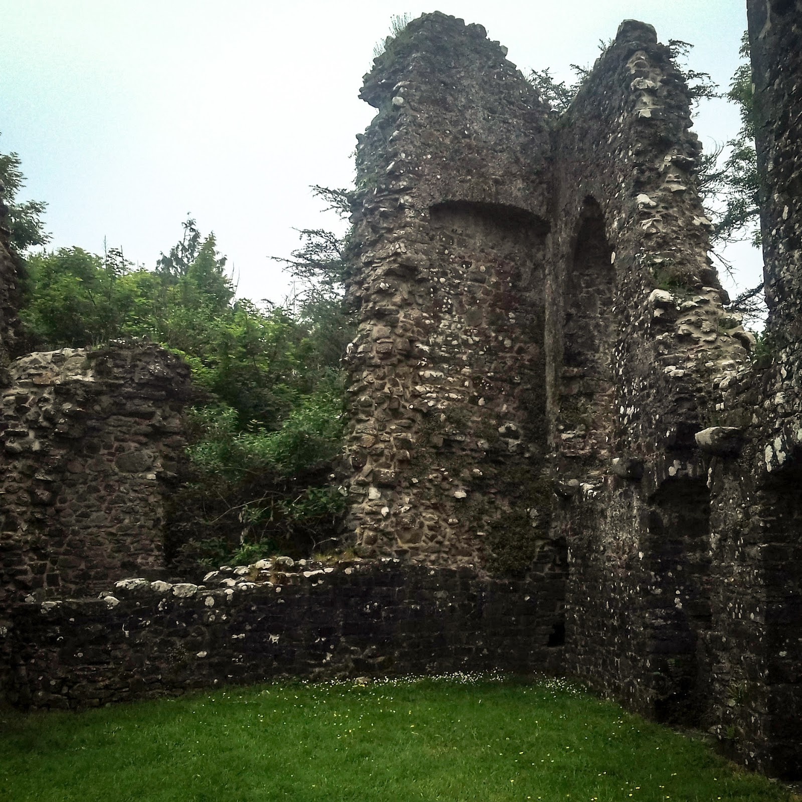
Remains of the castle sticking up like fangs from the ground

The castle was up a different path. You can't see much of it from the road, only one of the towers, but once up there, a lot more of the castle is visible. It is hard, from what is left, to visualise that it was once a mighty fortress, at least the second built on that site, and was built sometime after 1246 (you can read the CADW page ::here::). There were signs around the place with artist's impressions of the original castle, but I think the windows in the paintings are a tad more Gothic than might have been based on the actual window shapes remaining. However, there may have been more pointed tracery in stone frames now long gone. 

This is just part of a broken tower, once attached to a building
It was a damp, muggy day, with a dull grey sky, so I apologise in advance for the photographs being hazy and the skies being boring. I took all the photographs on my phone, as well, as I still haven't got a replacement camera. I'm currently unemployed, so it will be a while before I can afford a decent camera.

Raven was there too, and he took a couple of pictures of me.

Window into the cellar
The most complete part of the building is the pantry/kitchen cellar, with its tough barrel vault weathering the test of time. It's the building that Raven's standing in front of in the picture above. A lot of the stone from the castle was reused to build the town/village of Narberth (Arberth in Welsh) that surrounds. It's a very craggy-looking ruin, and the exterior walls, which would have likely been rendered and whitewashed to avoid the stone walls providing hand-holds, and to add an extra layer of protection from the elements, are now bare, with much of the walls' cores exposed. 

What is left of the great hall. 
The castle was built on a promontory, with a steep drop down to the graveyard below, and even further to the current road level. Geographically, it's quite a defensible location. I think the castle walls merge into a deliberate escarpment to the right of the buildings pictured above. Looking out over the trees now is quite magical. The vegetation there is very lush - West Wales is where parts of what is known as the 'Celtic Rainforest' grows - dense and green, watered by the decidedly soggy climate and warmed by the warm air currents that pass the West of the British Isles, brought by the Gulf Stream. 

Through the windows
The buildings were stabilised in 2005, after an extensive project to stop further ruination of what is left. Unfortunately, there has been graffiti since then, limiting what I could photograph (I don't want to put swear words, crudely drawn phallic images and suchlike on my blog) and also damaging the stonework as it would be difficult to remove the spray paint from the walls without also damaging the surfaces of the stones. It saddens me that I often go to castles and other ancient monuments and there's litter, beer cans (and sometimes worse) and graffiti - the results of people disrespecting their heritage. Ones that charge for entry tend to have less, but I think it's more the supervision of stewards than the price that changes things. 

I went through that doorway.
I did see a family taking their children for a stroll, which is a good thing - nice to see children being taken to such things at young age, hopefully to grow up more respectful of the castle than those who spray-painted the graffiti. I get really angry about people damaging historical buildings.

Inside what's left of the great hall
You can see corbels jutting from the walls where once sat the joists for the first floor. I don't know if there was a second storey on this part. The towers definitely had ground floor, first floor and second floor at least, probably with battlements behind crenelations. All of that is gone now. You can also see where they changed their mind about a window and walled it up into an alcove. 

Note corbel and hole in the wall where a beam once slotted in
I probably spent longer exploring and taking photographs than we really had time for. I find such ruins quite captivating. 800 years is pretty ancient in many ways, but it's actually relatively recent in Welsh history. Near Narberth/Arberth is a truly ancient hill-fort that is thousands of years old. It's somewhat overwhelming at times just how much history there is, layered all around us. I'll have to visit more of the really ancient stuff and blog about that, too. 


The arches are roughly Gothic, but it's hard to tell what the windows looked like with any more detail than that. The castle, like most medieval castles, also had a chapel, which I would expect to have church-like Gothic windows, maybe once having stained glass. Now there's just a hole in the wall. I wonder what happened to the glass. 

The hat and cloak make me look particularly severe.
Raven took a picture of me looking very serious by a window. I'm such a tourist sometimes - I want an 'I was there' picture of me at the places I visit. You can see how much better the resolution is on Raven's phone camera than on mine. I visited two other castles while I was in Wales, and I'll update my blog with those in the near future.